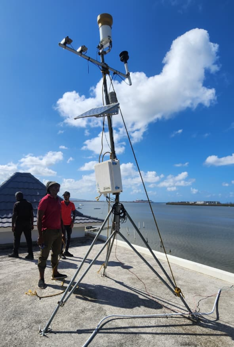
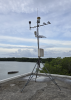
The automated weather station bolted to the roof of the Glistening Waters Hotel
(Photo courtesy of Dr. Ashley Matheny, University of Texas)

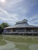
At the northern edge of Jamaica, fresh water from a limestone aquifer and the Martha Brae River flow into Oyster Bay and mingle with the salty Caribbean Sea. This mixture creates a unique ecosystem that sustains one of Jamaica’s most striking phenomenon: a glowing, bioluminescent lagoon.
Beyond the shimmering waterline, mangroves line the coast. While mangroves are known for surviving in saltwater environments, in Oyster Bay, they have access to both the salt water from the ocean and fresh water from the limestone aquifer and the river. They can tap into freshwater when it’s available. This may change how mangroves grow, store carbon, and recover from disturbances.
“Even though most people associate mangroves growing in salt water, it’s less energetically costly for mangroves to take up fresh water with their roots than it is for salt water,” said Dr. Ashley Matheny, a leading mangrove researcher based at the University of Texas. “In locations where they can access a shallow freshwater aquifer, they will root into the aquifer rather than taking up all of their water from the seawater.”
In 2018, Dr. Matheny purchased a Campbell Scientific weather station and deployed it in Texas. After the relocation of some equipment, the station ended up in Oyster Bay near Falmouth, Trelawny Parish, Jamaica on the rooftop of the locally owned Glistening Waters Hotel.
While the weather station was originally brought to Jamaica to better understand how meteorological conditions impact the mangrove ecosystem, it unexpectedly captured hurricane-force data as the storm made its exit from Jamaica.
Before Hurricane Melissa
In October 2025, Dr. Matheny was in Texas when she received word that a hurricane could make landfall in Jamaica. She anxiously watched as forecasts showed the storm growing from a Category 1 to a Category 5 hurricane.
As Hurricane Melissa steered toward Jamaica, the National Oceanic and Atmospheric Administration’s (NOAA) hurricane hunter airplanes deployed dropsondes into the then-oceanic hurricane and reported record-breaking wind speeds of 252 mph (approximately 406 kph/219 knots) (Merket 2025)1.
While Dr. Matheny’s primary concern was about the health and safety of her friends and colleagues in Jamaica, she was also concerned that the weather station would catch the wind, and the flying debris would injure individuals in the area. Even worse, she envisioned the station, mounted to the hotel’s roof, taking part of the roof with it as it soared through the hurricane-force winds.
While she contacted her scientific collaborators in Jamaica to see if they could remove the boom and reduce the weather station’s aerodynamics, the storm intensified too quickly, and no one was able to safely access the weather station before the storm hit.
The station would have to weather the Category 5 system exactly as it had been installed.
Installation Decisions That Made the Difference
Deliberate installation choices—made months prior to Hurricane Melissa making landfall in Jamaica—increased the weather station’s resilience. For researchers deploying instrumentation in extreme environments, this storm reinforced two principles:
- Structural anchoring is critical. The station was secured to the hotel's rooftop using masonry bolts installed by Dr. Camilo Trench of the Discovery Bay Marine Lab. In sustained hurricane-force winds, uplift pressures often reach hundreds of pounds. Proper anchoring prevented the station from becoming airborne and protected both the equipment and the structure beneath it.
- Grounding protects more than data. During a routine visit, Dr. Matheny noticed the station was not grounded and corrected it immediately. Proper grounding reduces the risk of surge damage and is a critical safeguard in tropical storms. That simple decision likely prevented far more extensive equipment failure.
During Hurricane Melissa
On October 28, 2025, Hurricane Melissa made landfall on Jamaica’s southwestern coast in New Hope. Monitoring stations in this area were limited, but NOAA and the National Weather Service (NWS) estimates that wind speeds at landfall were 160 knots (approximately 184 mph/296 kph) (Kelly, Álamo and Mahone 2026)2.
The hurricane rippled across the island from the southwestern coast where it made landfall to the northern edge where it exited the island, leaving a path of destruction in its wake. Precipitation from the hurricane flooded riverways. Critical infrastructure, including hospitals and communications lines, were damaged. Roofs were blown from homes, and wooden structures toppled in the winds.
After Hurricane Melissa
In the days following, critical communication lines were down in Jamaica. Dr. Matheny didn’t know if her collaborators and friends, much less the meteorological station, had weathered the storm.
Dr. Matheny got her first sign that the Glistening Waters Hotel and her weather station might have survived the storm in an unexpected way. Airplanes from NOAA began tracking the hurricane’s path. Equipped with high-resolution cameras, the NOAA planes prioritized areas of the island most severely impacted by the storm, starting with where the hurricane first made landfall before moving to the next-most-impacted area: Falmouth, Jamaica.
“I was able to zoom in on NOAA’s imagery and [say] ‘There’s my hotel…There’s our portion of the roof…I see a shadow…I see my weather station!’” commented Dr. Matheny. “So, I knew from zooming in two days before I got word from my colleagues that the weather station had made it.”
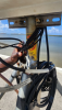
With minimal damage—a bent center mast with a non-functioning WindSonic1 2-D Wind Sensor and CS100 Barometric Pressure Sensor—the station had survived the hurricane intact.
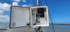
After a few days, Dr. Matheny got another unexpected message: shortly after critical communications on the island were restored, Sweelan Renaud, an intern for Dr. Trench, messaged Dr. Matheny on WhatsApp, indicating that she was safe, as well as sharing weather station photos. Using the USB port on the CR6 High-Capacity Data Acquisition System, Renaud sent Dr. Matheny the data files for further analysis.
“Holy cow! Not only did the station survive, but we have data coming in from when the storm hit!” exclaimed Dr. Matheny.
Despite hurricane-force winds, dramatic pressure shifts, temperature changes, flying debris, and salt spray from the ocean, the station had logged data continuously throughout a Category 5 hurricane.
Collaboration and Resilience
If you ask Dr. Matheny for advice, she’ll smile and say, “Science is better with friends.” She credits her collaborators, from Dr. Trench and Renaud to the owners of the Glistening Waters Hotel and the dozens of others who contributed to the project’s success. While measurements enable greater scientific understanding, true scientific resilience comes from collaboration.
Ground-based hurricane data, such as Dr. Matheny’s, are critical in advancing scientific understanding of extreme weather events, forecasting practices, and emergency resilience techniques. Dr. Matheny’s work contributes to a deeper insight into hurricanes and a broader understanding of mangroves.
References
1Merket, Audrey. 2025. National Science Foundation News. November 19. Accessed February 25, 2026. https://news.ucar.edu/133047/record-breaking-winds-confirmed-hurricane-melissa.
2Kelly, Larry A., José Álamo, and Aidan D. Mahoney. 2026. Hurricane Melissa (AL132025): 21-31 October 2025. Tropical Cyclone Report, National Hurricane Center.
Case Study Summary
Application
Monitoring weather conditions for a mangrove ecosystem and a hurricaneLocation
Oyster Bay near Falmouth, JamaicaProducts Used
CR6 CS320 CS655-L LI190R-L LWS TE525-L WINDSONIC1-LParticipating Organizations
University of Texas, Discovery Bay Marine LaboratoryMeasured Parameters
Solar radiation, soil moisture and temperature, barometric pressure, precipitation, wind speed and direction, leaf wetness, photosynthetic photon flux density (PPFD)View the PDF