The Oklahoma Mesonetwork is a statewide environmental monitoring network developed through the cooperative efforts of Oklahoma State University and the University of Oklahoma. The Mesonet is a bold, ambitious project to make timely and useful weather information available to the citizens of Oklahoma.
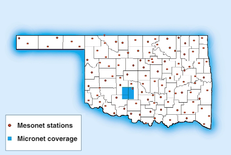
The Mesonet consists of 114 CR10T-based automated weather stations that continuously measure an array of weather and soil instrumentation. An additional 42 Mesonet-like stations in a dense Micronet over the Little Washita watershed are funded by the Agricultural Research Service. Each CR10T stores five-minute data summaries and is polled every 15 minutes. Data are relayed from each remote station to a central processing site. This rapid and reliable data transfer is accomplished using a combination of radiotelemetry (RF95T and RF232T modems), the Oklahoma Law Enforcement Telecommunications System (OLETS—an agency of the Oklahoma Department of Public Safety), and Campbell Scientific’s Real-Time Monitoring Software (RTMS) package.
The central processing site, or base station, is located in the Oklahoma Climatological Survey (OCS) in Norman, Oklahoma. The central processing site consists of an IBM-compatible 486 PC running OS/2 and RTMS as well as a VAX computer system for data handling.
The RTMS network communications software package provides the operational features associated with two-way communication. This minimizes transmissions required from the central site.
Remote operations executable from the central site include:
- Setting the weather station clock
- Downloading weather station programs
- Retrieving stored data following periods of communication failure
- Conditional selecting of alternate reporting intervals or output variables (This feature was especially useful for the Mesonet, which collected one-minute solar radiation data during the May 1994 annular eclipse.)
- Real-time monitoring of instantaneous measurements
The RTMS computer collects data from the OLETS high-speed data link, checks for any missing reporting stations, and then sends the data to an on-line VAX system over a TCP/IP link. The VAX checks the data quality, manages data storage, and assists in disseminating the observations and certain value-added products to a statewide community of users–all within minutes of each observation time.
Data are distributed by the OCS via computer networks and bulletin boards, print and electronic media, and interactive public displays. The Mesonet’s computer bulletin board system logged nearly 0.5 million minutes of on-line connect time during the first nine months of 1994.
In June, the Mesonet collected 1,278,591 out of 1,278,720 possible observations. After all data holes were filled using RTMS software, only 129 observations failed to be collected. This means 99.9899 percent of the possible observations were achieved. For current information visit the Mesonet website at http://okmesonet.ocs.ou.edu.
Case Study Summary
Application
State-wide environmental monitoring network measuring weather and soil parametersLocation
Oklahoma, USAContributors
Dr. Ken Crawford, director, Oklahoma Climatological Survey, Norman, OKParticipating Organizations
Oklahoma State University, University of Oklahoma, Oklahoma Climatological SurveyMeasured Parameters
Air and soil temperature, RH, wind speed and direction, barometric pressure, solar radiation, rainfall, soil moistureRelated Website
Oklahoma Mesonet Web site Oklahoma Climatological Survey ARS MicronetView the PDF